|

Summer 2001 (9.2)
Pages
14-23

Above:
Trekking
up Babadagh.
Spectacular
scenery, fresh air, blue skies and the adventure of discovery
are reasons enough to go hiking out in Azerbaijan's countryside.
But perhaps the best reason is its welcome escape from the bustling
city and hectic workweeks. Out there are broad, serene landscapes
seemingly untouched by civilization. You soon find that there's
much more to Azerbaijan than just Baku. It's an entirely different
world.
During the past three years while on assignment here in Azerbaijan,
my wife Leslie and I have enjoyed many day trips outside of the
capital, most of them organized to take us just a few hours'
distance from the city. Once you get outside of Baku, there are
many interesting and accessible places worth visiting, especially
in the Caucasus mountains. There are so many places where the
countryside is essentially wide open, and walking is not very
strenuous. Unlike Britain, where I grew up and hiked since my
Boy Scout days, there are no marked paths, no signposts and few
fences to obstruct the path or view. Almost all land is treated
essentially as public property.
  Left: The slopes up from the Pirgulu Observatory
make for excellent cross-country skiing in the winter. Left: The slopes up from the Pirgulu Observatory
make for excellent cross-country skiing in the winter.
The
best time of year for walking, I think, is spring - April, May
and June. That's when the weather is best and the countryside,
its lushest green. Of course, you can walk at any time of year
in Azerbaijan; however, you'll find that higher altitudes are
inaccessible in winter because of the ice and snow. But at the
lower levels, the winters are usually not severe. The summer
months can be unseasonably hot and dry, making for difficult
and labored walking at the lower altitudes. But if you go high
enough, above 1,500 meters, you'll find it very enjoyable in
the summer.
Snakes
While there are poisonous snakes in Azerbaijan, especially in
the hot plains, it's been rare for us to see them in the mountains.
We have seen them on the Absheron Peninsula, particularly toward
the tip end of the archipelago (Shah Dili), where there used
to be a snake farm. [See "Droplets
of Life or Death, The Venom of Caucasian Vipers" in Azerbaijan International
3.2, Summer 1995.]
Sheep Dogs
Often on our hikes, we meet shepherds grazing their flocks of
sheep and goats. We've found them to be welcoming and friendly.
But one note of caution: their sheep dogs can be quite aggressive,
as they are there to protect the flocks and don't seem to comprehend
that we aren't a threat to the sheep. Sometimes waving our walking
sticks at them doesn't seem to do much good, so we've had to
resort to throwing stones to keep them at bay until we pass the
flock. Some people carry along dog-deterrent pepper spray that
they bring from the States.
Flooding
Another thing to watch out for, especially in the mountains,
is flooding and landslides. In the spring, the rivers become
swollen with melting snow. You don't want to be caught up in
the mountains in the middle of a storm. Be alert for flooding
any time that it's raining and also when the snows melt in spring
and early summer. Because the peaks of the mountains are very
high and the sea is relatively close, this results in extremely
rapid currents in the swollen river washes. The valleys tend
to be very wide; consequently, the rivers are known as "braided
rivers" because they resemble the appearance of hair braids
with their many interwoven streams.
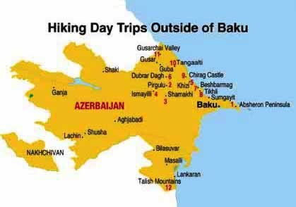
Above: Recommended places
for hikes in Azerbaijan, numbered according to their order in
this article.
Dangerous Roads
Because of the poor road conditions, you'll definitely want to
make sure your driver is quite experienced. In the Caucasus,
the narrow roads hug the side of the mountains and are usually
hard-packed dirt except when it rains and they become deeply
rutted. There are no guardrails on the roads, and sometimes there
are steep drop-offs plunging into ravines hundreds of feet below.
Watch out for landslides any time of the year and for boulders
blocking the passage.
Go as a Convoy
For safety's sake, it's a good idea to go together with friends
in a convoy of several vehicles - four-wheel-drives. If you run
into trouble, another vehicle can come to the rescue. There's
no tow-truck service. Usually, we arrange for a driver to take
us to a drop-off point and then pick us up later at a designated
location often several hours' hike away. Sometimes it takes the
driver nearly as long to reach the destination, if he has to
navigate on a different mountain range. We instruct the driver
to meet us at a specific place and estimate the general time
frame that we plan to arrive if all goes well.
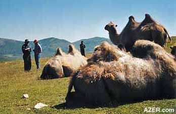 Left: Although caravans no longer pass through
Azerbaijan on the Silk Route, camels though quite rare can still
be found in the Pirgulu area. Left: Although caravans no longer pass through
Azerbaijan on the Silk Route, camels though quite rare can still
be found in the Pirgulu area.
What to Bring
Maps
At Azerbaijan's Institute of Geology, you can get very detailed
topographic maps showing the elevations, valleys, rivers, vegetation
and wooded areas. The maps will also show the dirt roads and
tracks between villages. These maps are as detailed as the ones
you get in European countries or North America. Ask for the Azerbaijan
Republic Map with detailed topography at the Academic Book Store
at 51 Istiglaliyyat Street across from the Presideum of the Academy
of Sciences.
Elliott's Trailblazer
Guide
You don't absolutely need a map, however, because the countryside
is so wide open. You can just pick an area that you want to go
to and set off. Mark Elliott's "Azerbaijan with Georgia"
(Trailblazer Publications, 1999) is also an indispensable guidebook
for four-wheel driving and walking routes. Mark is an avid hiker
himself and has included more than 140 valuable hand-drawn maps
in the guide.
Water
Make sure to bring lots of water, at least a liter per person
for hikes of just a few hours' duration; much more, of course,
for longer jaunts. That goes for food as well. We usually pack
up sandwiches, nuts and raisins.
 Clothing Clothing
When you pack clothing, consider that there may be unexpected
changes in the weather. When you set out, it may be nice and
comfortable, but bring warmer clothing just in case you get stuck
somewhere overnight. Be prepared for showers in the mountains,
even in the summer and fall.
Left: Layers of geologic
time make for spectacular scenery in Pirgulu and many other places
throughout the countryside.
First Aid Kit
Of course, the No. 1 necessity is a first-aid kit. Also it's
important to bring a warm emergency blanket in case you ever
have to spend the night unexpectedly out-of-doors. Fortunately,
we've never had to use ours. A compass is necessary, as you can
easily get lost in wooded areas. Matches and a knife also come
in handy. And, of course, a walking stick.
Emergencies
Although it may be possible to get help in an emergency, you
want to be as prepared as possible to handle a crisis on your
own. On one of our longer walks, some of the hikers twisted their
knees and had trouble coming back down the steep slope. The local
shepherds were immensely helpful and quick to assist; they went
up the mountains with their horses and brought the injured hikers
down on horseback.
 Mobile Phone Mobile Phone
Finally, a mobile phone is invaluable. Over the past three years,
Azerbaijan's cell phone network has become much more extensive.
Though it doesn't cover the entire country, it provides surprisingly
wide coverage. It pays to be familiar with the locations of mobile
phone antennas, in order to anticipate where you might be out
of range.
Left: The isolated village
of Khinalig, only accessible for a few months out of the year.
Its residents speak a little-known, unwritten language.
What You'll See
Spectacular scenery for starters! There are steep inclines, gorges,
ravines, wide-open spaces so vast and so serene that you often
forget that others have also passed the same way before you.
In the springtime, it's always amazing to see the fields blanketed
with wildflowers. You'll find a variety of colors, especially
reds and yellows, blues, purples and whites. In the higher altitudes,
the flowers continue to bloom throughout the summer.
The waterfalls are also spectacular. Since the mountains are
fairly close to the sea, the water cascades down from a considerable
height, creating a dramatic effect.
The shepherds that we've encountered have always been very friendly
and treated us as guests, often offering us tea. Sometimes they've
invited us into their tents. It's always amazing to learn how
far they've come on foot with their flocks during the summer
months, when they make the ascent to higher climes. Distances
of 50 to 100 kilometers are not unusual.
Sometimes you come across the unexpected in the Caucasus. Once
when we were approaching the isolated village of Khinalig, which
is only accessible, even by four-wheel-drive, for a few months
out of the year, we came up to the brow of a hill only to discover
20 to 30 people riding on horseback toward us. It was like a
scene right out of the movies. Of course, we greeted them. They
seemed to come out of nowhere. We had no idea where they were
coming from or where they were going, but it was a remarkable
sight.
 Good Places to Hike in Azerbaijan Good Places to Hike in Azerbaijan
Most are one-day trips out of Baku.
Left:
Beshbarmag"
means "Five Fingers".
1. Absheron
Peninsula
Less than an hour's distance from Baku, on the north coast of
the peninsula, there's a pleasant walk of a couple of hours along
the low cliffs, starting east of private "baghs" or
"dachas" ("summer" homes) beyond the power
station at Shuvalan. There are also sandy beaches extending as
far as the small port of Dubandi. Beyond that, you'll find a
lighthouse overlooking Pirallahi Island and its run-down oilfield
installations.
On the other side of the peninsula - that long, thin tongue of
Shah Dili (on the Absheron archipelago) - the land extends south
into the Caspian Sea, with pathways or beaches on either side
of the archipelago. This is a national refuge area, and you're
in for a treat if you hike here in the winter when thousands
upon thousands of birds migrate southward with a stopover in
Azerbaijan.
2. Pirgulu
The asphalt road from Shamakhi to Pirgulu is open most of the
year and is a favorite day trip by car from Baku. The cabins
near the Observatory are a good place to stay overnight, in summer
or winter. There are several walking routes from here, into the
valleys to the north and south, passing through low woods. The
slopes up from the Observatory are also good for cross-country
skiing.
For a longer trip, these slopes eventually lead to the mountain
ridges above Lahij, which can be walked in a long day. (It's
about 25 km and a rather steep descent.) At the end of the climb,
there's the prospect of a hot bath in a 19th century bathhouse/sauna,
a meal of shashlik (lamb kabab) and a bed at the adjacent farmer's
house near the stream as you enter the village.
3. South of Shamakhi
The roads south of Shamakhi run through open grasslands. Side
roads lead to spurs and river valleys heading to Aghsu and the
dry central plain of Azerbaijan. In the spring these hills are
covered with wildflowers, and if the air is clear, there are
excellent views of the valley across to the Lesser Caucasus and
Karabakh.

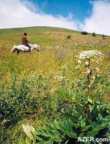
Above:
Shepherds
traditional move with their families and flocks to the higher
elevations during the summer time. Location is Gris.
4. Ismayilli
The valleys northwest of Ismayilli are interesting places to
explore. This region is about the limit in distance that one
can do comfortably in a day trip from Baku. Areas on the south
side of the main chain of the Caucasus are designated as national
parks. The sizeable village of Galajig is very welcoming, with
many old houses set among the trees. Above the village, the valleys
climb up to open meadows, providing excellent opportunities for
walking.
5. Khizi
The road to Khizi heads west from Gilazi, an hour north of Baku.
It passes the spectacular "Candy Cane" mountains that
are composed of different colored shale before reaching the small
town of Khizi. Leading west in the valley after Khizi, dirt roads
head up a narrowing valley and into very thick woods, much of
them beech. There's a path leading up past a small waterfall
that reaches open farmland after a few kilometers and a few hundred
meters' climb. From there, one can either return by the same
route or head west down the steep slopes to the Altiaghaj road.
There's also a route south to the woods to Larimja, from which
another good dirt road leads to Altiaghaj.

Above: Though Azerbaijan's
country landscapes are full of serenity and solitude, there is
much evidence that others, too, have enjoyed the same expansive
views. At Gris.
6. Dubrar Dagh
This is a peak with an altitude of 2,000 meters to climb from
a dirt track off the road to Altiaghaj. This trail starts near
the mineral-water collection station and climbs several hundred
meters. The hills are not wooded, so there are good views when
it's clear. You'll find many shepherds with their flocks there
in the summer.
7. Beshbarmag
The name of this dramatically shaped mountain translates as "Five
Fingers". It's another favorite place that attracts many
tourists in every season. There's a considerable difference in
the landscape with the seasons. In the winter and spring, the
mountain is blanketed in lush green; in the summer and autumn,
everything has baked under the sun and turns yellow-brown. When
drivers pass this point on the road to Guba, they know they are
finally arriving at the rich farmlands and orchards of northern
Azerbaijan. Beshbarmag can be climbed "direct" from
the new mosque along the main road, or one can take a different
route up along the ridge from the valley leading from the Zarat
DYP (Dovlat Yol Polisi - National Highway Patrol).
Left: June is the best time
of year to visit the waterfall at Gizildagh.
Right: Compared to other old
fortresses in Azerbaijan, Chirag Castle is in fairly good condition.
8. Tikhli to Beshbarmag
This is a 4-5 hour walk from the village before Khizi, heading
east across the ridges and valleys, to Beshbarmag. In spring
the wildflowers are very colorful, and as you ascend each ridge,
you'll enjoy ever-closer views of the "Five Finger"
mountain.
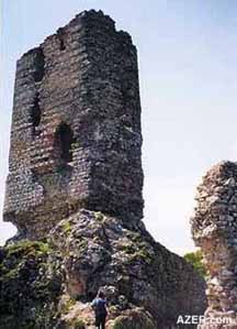
9. Chirag
Castle
Another popular destination for family outings, by car, or larger
groups by bus, is Chirag Castle. This fortress, though in desperate
need of repair, is one of the most impressive ancient towers
of the region. Built in the 5th century by the Sassanids, the
castle was used up through the 18th century as part of the southern
defenses of the khanate of Guba. It can be reached by the asphalt
road from Davachi, past the sanatorium at Galaalti or from the
road from Siyazan through the oilfield. Good walks can be made
up the ridge north of the castle through dense woods. There's
also a 6-km hike from the village of Dashlig Yanar along the
ridge toward the castle, with changing views of it en route.
Left: Ambling through a meadow
near Tangialti. Right:
Gizildagh.
10. Tangaalti Gorge
South of the Guba road, there are several ways to reach the gorge
of Tangaalti. This countryside is very fertile, watered by rivers
that originate high in the Caucasus. Beyond the gorge, the valley
opens up again with excellent places to hike in the hills on
either side. There are some impressive cliffs on the southern
side, and a good walk up to about 1,900 meters from the villages
above the dirt road that crosses the river about a kilometer
south of the gorge. On clear days there are excellent views across
the foothills to the Caspian sea.
11. Gusarchai
Valley
The valley heading up into the mountains southwest of Gusar is
fascinating and full of places to walk. From the village of Anig,
there's a hike up a side valley over to the next river, which
leads to the Long Forest Resort and the Guba-Gusar road. Further
up the Gusarchai valley, the dirt road becomes steeper and is
difficult in wet weather, but it leads to the village of Laza
with its famous waterfalls.
The hike up the valley from Laza is alpine in beauty, with the
peaks of Gizildagh and Shahdagh towering above Gusarchai's cascading
waterfalls.
For an overnight walk, this route can be followed through a pass
to the isolated village of Khinalig, about 15 kilometers from
Laza, which is accessible by road only about two or three months
of the year because of the rivers one must ford. Khinalig is
known for having its own distinct language.

Above:
Open skies,
open shore along the Caspian coastline.
12. Talish Mountains
Though too far away for a single day trip, the Talish mountains
of southern Azerbaijan are beautiful places to drive through
and to hike. The first 20 kilometers or so up the valleys to
Yardimli and Lerik are thickly wooded, but with many paths to
explore.
Lerik is famous as a region for its number of centenarians. Further
up, the woods give way to open farmland and grassland with many
villages. Around Yardimli, paths lead to the rolling hills of
the border region with Iran. Beyond Lerik, there are higher peaks,
begging to be explored.
John Connor is Chevron's General
Manager in Baku. During the past three years on assignment in
Azerbaijan, he and his wife Leslie have enjoyed hiking in the
Caucasus, usually on day trips from Baku.
_____
From Azerbaijan
International
(9.2) Summer 2001.
© Azerbaijan International 2001. All rights reserved.
Back to Index
AI 9.2 (Summer 2001)
AI Home
| Magazine Choice | Topics
| Store
| Contact
us
|